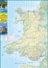
Wales & Southwest England Travel & Road Map. Double sided map showing roads, railway, ferry routes with travel times, and long distance paths. Includes all points of interest and is color coded to elevation. Insets include Channel Islands, Isles of Sicily.
Double sided map showing roads, railway, ferry routes with travel times, and long distance paths. Includes all points of interest and is color coded to elevation. Insets include Channel Islands, Isles of Sicily.