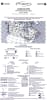
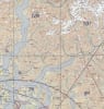
VNC 5004 Vancouver Navigation Chart. The VFR Navigation Chart (VNC) is used by VFR pilots on short to extended cross-country flights at low to medium altitudes and at low to medium airspeeds. The chart displays aeronautical information and sufficient topographic detail to facilitate air navigation through the use of a unique colour scheme, layer tinting, and shaded relief. There are 52 charts in the series. The scale is 1:500,000.
 is used by VFR pilots on short to extended cross-country flights at low to medium altitudes and at low to medium airspeeds. The chart displays aeronautical information and sufficient topo")