North Shore Trail Map - Waterproof. This North Shore trail map will appeal to those who enjoy walking, hiking, mountain biking or are mountaineering enthusiasts. Use this map to find trails to the best walks, hikes, rides, peaks, lakes, viewpoints, waterfalls, picnic sites and old growth trees on the North Shore.
The most accurate and detailed North Shore trail map ever produced
Includes the first trail map of the entire Howe Sound Crest Trail
This double-sided map shows the main walking, hiking & biking trails on the entire North Shore
Includes Sea-to-Sky section from Horseshoe Bay to Porteau Cove
Waterproof & tear resistant – if cared for properly, this map will last for many years
1:20,000 scale
Locator map & access roads shown
Cypress Provincial Park, Lynn Headwaters Regional Park & Mt. Seymour Provincial Park included
Lower Seymour Conservation Reserve, Capilano River Regional Park & Lynn Canyon Park included
Porteau Cove Provincial Park, Nelson Canyon Park & Cypress Falls Park included
Map area stretches from the Trans-Canada Hwy to Porteau Cove (S to N) and from Horseshoe Bay to Deep Cove (W to E)
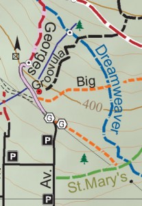
EXCEPTIONAL HIKING TRAIL DETAIL
Additional Features of North Shore Map:
Topographic map with elevation colouring and hill shading
UTM grid (with 1 km gridlines) as well as latitude/longitude grid for easy GPS use
Contour interval: 20m
All backroads, tracks, trails, routes and mountaineering routes were GPSed from 2010 to 2017
Mountain bike trails are shown according to difficulty (green, blue & black)
This map was prepared with attention to detail. All roads are rated according to roadEXCEPTIONAL MOUNTAIN BIKE TRAIL DETAIL
conditions: paved road, 2WD road, 2WD High Clearance road, and 4WD road. Likewise, trails and routes are rated to help guide users through the map area: track, primary trail, secondary trail, route and mountaineering route. In addition, small side creek and trailside pond positions, not indicated on any other maps, are shown for navigation purposes. Trail Ventures BC’s maps are based on extensive, detailed field surveys conducted on foot
Locations of parking, campgrounds, backcountry campsites, backcountry shelters, picnic sites, outhouses/restrooms, footbridges, waterfalls, viewpoints, major creek crossings, gates, historic sites, information boards, fish hatcheries and old growth trees are shown
Map projection/datum: NAD83. UTM gridlines plus gradations on the outside of map frame; and lat/long gradations on inside of map frame
General information regarding activities are given for all parks, reserves and recreational areas
Important phone numbers and web sites are listed
2nd Edition Improvements over 1st Edition
Several new hiking and mountain bike trails added. Closed trails and footbridges have been deleted. Trail closure area added. Parking areas updated. Improved park boundary positions. Magnetic north declination and declination change added. Improved display of some symbols. Corrected and added new geographical names. And many other changes for reasons of aesthetics, declutter, accuracy, etc.