QUESTIONS? GIVE US A CALL! 1 (877) 921-6277 or (403) 266-2241
WE SHIP EVERYWHERE!
QUESTIONS? GIVE US A CALL! 1 (877) 921-6277 or (403) 266-2241
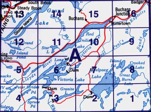
Use the following image to move to adjacent topo map indexes.

Back to the Newfoundland and Labrador Topographic Maps Index.
12A - Red Indian Lake, 12A01 - Cold Spring Pond, 12A02 - Wolf Mountain, 12A03 - Burnt Pond, 12A04 - King George Iv Lake, 12A05 - Puddle Pond, 12A06 - Victoria Lake, 12A07 - Snowshoe Pond, 12A08 - Great Burnt Lake, 12A09 - Noel Paul'S Brook, 12A10 - Lake Ambrose, 12A11 - Star Lake, 12A12 - Little Grand Lake, 12A13 - Corner Brook, 12A14 - Rainy Lake, 12A15 - Buchans, 12A16 - Badger


