QUESTIONS? GIVE US A CALL! 1 (877) 921-6277 or (403) 266-2241
WE SHIP EVERYWHERE!
QUESTIONS? GIVE US A CALL! 1 (877) 921-6277 or (403) 266-2241
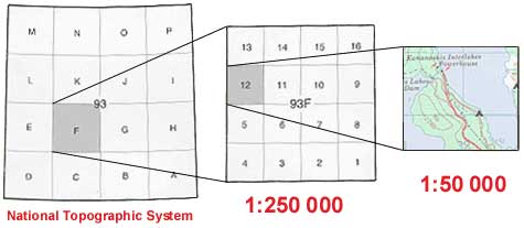
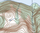
Canadian topographic maps (also known as "topo maps") come in two scales. The 1:50,000 scale topo map is the most detailed scale and covers an area of about 25 km by 40 km. Its high level of detail makes this scale topo map ideal for recreational activities, such as hiking, walking and bicycling. Accurately shown are hills, valleys, lakes, rivers, wooded areas and all man-made features such as buildings, powerlines, roads, dams and cut lines.
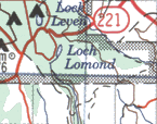
The 1:250,000 scale topographic map is more of an access map, for use in a vehicle than on foot. Each map sheet covers approximately 100 km by 160 km, the same area of land as 16 of the larger 1:50,000 scale maps. These topographic maps have gained popularity, not only for their detailed overview of a large area, but also as an excellent road map for exploring the back roads.
|  1:250,000 Scale Map |
|  1:50,000 Scale Map |
The area covered by a given map sheet is determined by its latitude and longitude. Because of the standard NTS numbering system, knowing the map number allows you to quickly identify adjacent maps.
|
|
|
|